
Research Report on 2009 Floods and Landslides Disasters Caused by Typhoons 16(Ondoy), 17(Pepeng) and 18(Sante) in the Philippines
9.Landslide Damage in the North Part of Luzon Island
1. Overview of landslide disasters and rainfall conditions
During the passage of typhoon Pepeng, Benguet province in the north part of Luzon island was subjected to torrential rain that caused numerous landslides and substantial human damage. The most damaging landslide occurred at a place called Little Kibungan in La Trinidad, Benguet province, where 85 people lost their lives (11 October, 2009). A survey of landslide disasters in Benguet province and the region surrounding Baguio city was conducted on 27 November. After interviewing the mayor, on-site surveys were performed in relation to the conditions of landslide disasters at 5 locations. The torrential rain brought by typhoon 17 (called typhoon Pepeng in the Philippines) mainly consisted of two peaks with complex movements involving the repeated landfall of this typhoon. In the initial period of torrential rain, 531 mm was recorded on 3 October in Baguio city. Subsequently, a total in excess of 1200 mm was recorded in the three-day period from 6-8 October (260 mm, 276 mm and 685 mm). Although the landslide disasters in Baguio happened at slightly different times, they were roughly clustered around the morning of the 8th.
2. Landslide conditions and the resulting damage
Although only a short-term survey was possible, we were able to base it on detailed reports and other materials gathered from the landslide locations. The landslide that caused the most damage occurred at Little Kibungan in La Trinidad, Benguet province. This landslide occurred along the road from Baguio to the Benguet province government offices. It cut across the road and flowed down into and along the valley below, destroying settlements and leaving 85 people dead. This landslide occurred on the embankment of the road passing through the slopes just below the mountain ridge, and on the slopes behind it. The landslide started on a very steep section approximately 30 m wide and 20 m high, and the cliff to the right of the landslide surface became a fault plane cutting across the slope (see Photos 1 and 2). Above the slope where the landslide took place, the terrain is very flat close to the mountain ridge. This suggests that the landslide may have been caused by rainwater permeating along the fault plane.
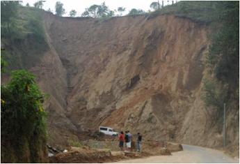
Photo 1: Location of the landslide in La Trinidad
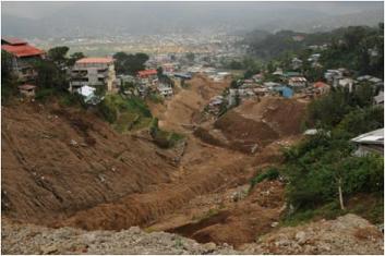
Photo 2: Conditions downstream of the La Trinidad landslide, and the disaster region
Many more fatalities were caused by other smaller landslides in Baguio city. At a number of locations where on-site surveys were performed, it was found that steep slopes below the hard shoulder of roads had collapsed, causing a flow of earth onto dwellings built on the slopes below (Photo 3). As discussed below, the concentration of population in Baguio city can be identified as one factor behind the scale of the landslide damage because it means that even steeply sloping regions are used for the construction of densely packed housing.
The landslides below the hard shoulder of the surveyed roads occurred in places where the roads were located on mountain ridges and there was almost no water catchment area. Thus, although the leakage of water from roadside drains may be a possible cause of these landslides (Photo 4), it is difficult to say for sure because a complete survey was not possible.
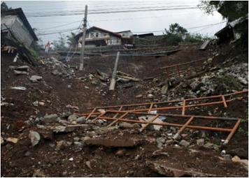
Photo 3: Landslide in a steep slope below a road (Crescencia Village)
Photo 4: A drainage pipe was installed in the hard shoulder
of the road running above the collapsed slope.
(at Kitma in Marcos Highway)
[ DIL TOP page | TOP page ]
