
Research Report on 2009 Floods and Landslides Disasters Caused by Typhoons 16(Ondoy), 17(Pepeng) and 18(Sante) in the Philippines
10. 2009 Typhoon Ondoy Flood in the Metro Manila.
10.2 Locality of flood disasters
(1) Hydrological environment
The flooding of Metro Manila varies according to the hydrological and geophysical environment of the flood plain. Table 1 shows characteristics of flooding and flood damage in Metro Manila, how the flood inundation and damage varied between flood plains. Inner water inundation may have also occurred in the river basins where there was severe external overflow, but this figure charts the inundation phenomena that caused most damage. Furthermore, administrative districts sometimes cross over multiple topological zones and were divided into their main topological areas.
As a result, the flooding of Metro Manila can be divided into regions where increased damage was mainly caused by external flooding, and regions where it was mainly caused by inner flooding. The Marikina flood plain and San Juan River valley plain can be placed in the former category and the Laguna Lake Plain and Coastal lowlands along the Manila bay coast can be placed in the latter, which can also be subdivided into the coastal lowlands which experienced a short flooding duration, and the Laguna Lake Plain where the flooding persisted for more than two weeks.
Table 1 Characteristics of flood disasters by Typhoon Ondoy in Metro Manila
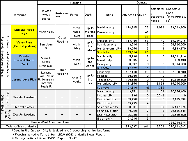
1) In the Marikina flood plain where damage was mainly caused by external flooding, overflow well in excess of twice the river channel discharge capacity occurred, and the water level in the river rose rapidly by approximately 3 meters in 3 hours. The large depth of flood water combined with the sharp increase in water level to result in a severe inundation that spread across the entire flood plain. Flood water depths of 7 m were recorded in some places, although the flooding was short-lived (JICA,2009; ADB,2009;P.B.GATAN,2009). The flood caused damage on a large scale, affecting many people and causing 121 deaths (half the total for Metro Manila). The flood plain lies mostly in Marikina city, but part of it extends upstream into Quezon City. In Marikina city alone, there were approximately 180,000 people affected by the flooding. Other problems included a high incidence of infectious disease, and environmental damage caused by the run-off of pollutants from small and medium scale factories in the river basin.
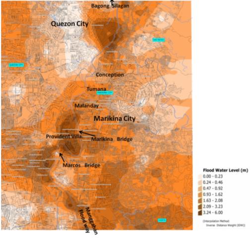
Fig.5 Inundation depth in Marikina Flood plain (NAMRIA, 2009)
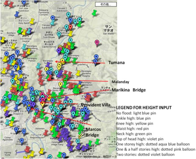
Fig.6 Maximum Inundation depth in Marikina Flood plain (Google, 2009)
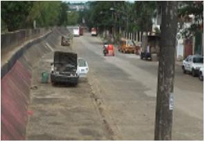
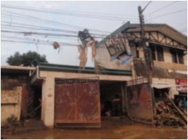
Photo 5 & 6 Provident village damaged by flooding (PNRC-Rizal, 2009)
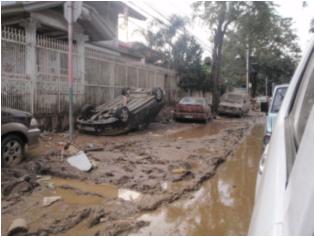
Photo 7 & 8 Provident village damaged by flooding (PNRC-Rizal, 2009).
2) In the valley plain along the San Juan River where damage was mainly caused by external flooding, there was an external flooding of flash-flood in small and medium-sized rivers descending from an altitude of 95 m to 3 m. At the Quezon City Science Garden inside the river basin, precipitation rates of 92 mm in 1 hour and 455.0 mm in 24 hours were observed, showing that this river basin was inflicted by a torrential downpour. Since the catchment area is only about one fifth the size of the Marikina River's catchment area, it is expected that flooding began earlier here than in the Marikina River. Also, since the flooded region of the valley plain is limited, this area is generally prone to more severe flooding with a greater depth of inundation. This area suffered the second highest level of destruction behind the Marikina flood plain, and there were 111 fatalities. The number of people affected in this river basin (which includes Quezon, San Juan and Mandaluyong Cities) reached 135,000.
Fig.7 Maximum Inundation depth in Marikina Flood plain (Google, 2009)
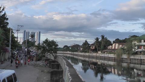
Photo 9 Floodwall along San Juan River
3) The Laguna Lake Plain was mainly affected by inner flooding and remained flooded for a long period of time. This is a low-lying marshy area with an elevation of just a few meters which was affected by the increased water level of Laguna de Bay and was deeply flooded with regions close to the lake shoreline remaining submerged for more than a month. Although the flood inundation was not as severe as in the Marikina flood plain, the flood water rose to a considerable depth, and the prolonged flood inundation resulted in the greatest number of affected people in the whole metropolitan area, reaching 400,000 people or 45% of the total. However, there were 26 fatalities in this region, which is about one fifth that of the Marikina flood plain.
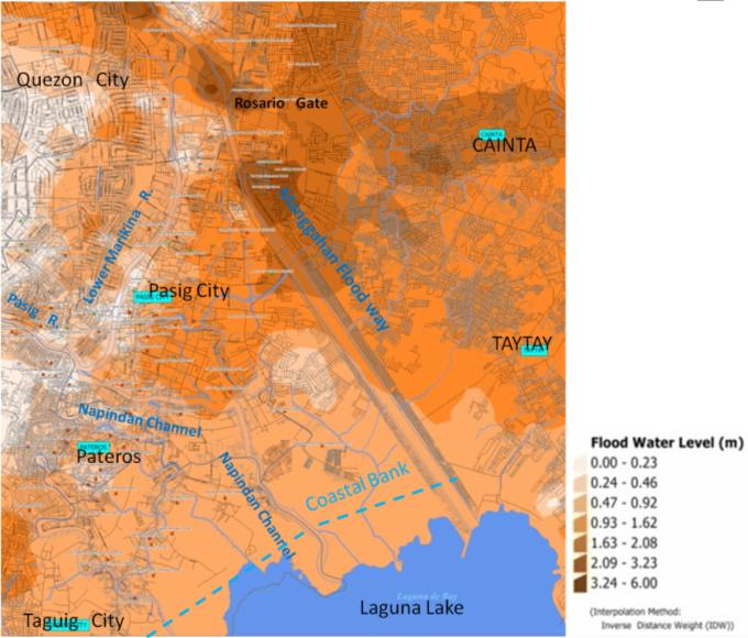
Fig.8 Inundation depth in Laguna Lake Plain (NAMRIA, 2009)
Fig.9 Maximum Inundation depth in the Laguna Lake Plain (Google, 2009)


Photo 10 & 11 Flooding along the Laguna Lake in Taguig City on Nov. 30, 2009.
4)Coastal lowland adjacent to Manila bay was mainly affected by inner flooding. This is a low-lying and poorly drained geophysical environment with an elevation of 3 meters or less. Here, the Pasig River was partly overflowed, but it was possible to continue operating the pumps that expel inner water from lowland areas. However, in the lowland areas it was not possible for the heavy rainfall to drain away, and inner water inundation occurred. This flooding was fairly short-lived (from half a day to a few days). As a result, the number of people affected in the coastal lowland was only about 5% of the total for Metro Manila as a whole, and there were only 19 fatalities in this area. This area includes the central metropolitan areas of Manila city, Makati city and Pasay city.
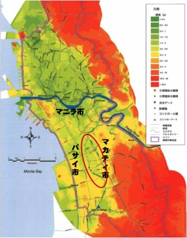
Fig.10 Geographical map of the Coastal Lowland along Mania Bay (JICA,2004)
The Pasig River flowing through the city center was spared from flooding due to the flooding of the Marikina River further upstream and due to the fact that the floodwater was diverted into Laguna de Bay from the Manggahan floodway and Napindan channel so that the flood discharge of the Pasig River was kept down to 600 m3/sec, which is just about within the river channel discharge capacity (500-600 m3/sec) (MMDA,2009; P.B.GATAN,2009). On the other hand, in the city drainage channel where the drainage capacity has decreased to the point where it can only cope with rainfall levels estimated to occur every 2-5 years, it was not possible to protect the city from the heavy rainfall caused by Typhoon Ondoy.
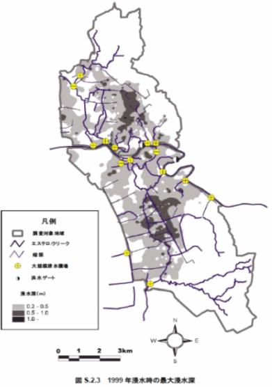
Fig.11 1999 Flood in the Coastal Lowland along Manila Bay(JICA,2005)
Fig.12 Maximum Inundation depth in the Laguna Lake Plain (Google, 2009)

Photo12 & 13 Inner Flooding in Makati City (taken by Kazutami Shiga)
[ DIL TOP page | TOP page ]
