
Research Report on 2009 Floods and Landslides Disasters Caused by Typhoons 16(Ondoy), 17(Pepeng) and 18(Sante) in the Philippines
6.Physical Characteristics of T0916 and T0917
T0916 (Asian name: Ketsana, PAGASA * name: Ondoy) formed on 26 September, 2009. It landed on Luzon island (Philippines) and the Indochinese Peninsula, then, and caused severe damage to the Philippines, Vietnam, Cambodia, and Laos. Finally, and it became a tropical depression around the Indochinese Peninsula on 30 September. Almost 80 percent of metropolitan Manila (Philippines) was left underwater. The total rainfall for the nine-hour deluge was 410.6 mm**, breaking the previous single-day record of 334.0 mm in July 1967. The minimum pressure was 960 hPa **, and the maximum wind speed was 35 m/s**.
Subsequently, T0917 (Asian name: Parma, PAGASA name: Pepeng) formed on 29 September, 2009. After repetition of landing on and leaving from Luzon, it moved on into the South China Sea. After easing off to a tropical depression, it strengthened again into a typhoon. It then landed on Nanhai island (China), and finally reverted to a tropical depression around the Gulf of Tonkin on 14 October. The minimum pressure was 930 hPa, and the maximum wind speed was 50 m/s.
Both typhoons caused severe damage in various parts of the Indochinese Peninsula, especially in the Philippines. There were three reasons for the large amount of damage; (1) T0917 was a very strong typhoon, (2) two typhoons, T0916 and T0917 formed and landed on Luzon in succession, and (3) T0917 remained stagnant around Luzon for a very long time with complex movement due to the interaction with T0918. The last of these is very interesting in terms of its physical characteristic. This is the so-called Fujiwhara effect, which was proposed by Dr. Sakuhei Fujiwhara, the then head of the Central Meteorological Observatory of Japan (Fujiwhara, 1921).
The Fujiwhara effect was originally defined as an interaction between two nearby typhoons (in general, vortices with the same rotating direction separated by up to around 1000 km), which causes their centers to begin orbiting cyclonically (in general, in the same rotating direction as the vortices themselves) about a point between the two systems. Recently, however, it is often used more generally to describe the interactions among two or more nearby typhoons. Real typhoons not only exhibit simple rotation but also undergo complex movements governed by the distances between them, their intensity, and the surrounding winds. Their behavior patterns are, for examples, classified into five types: (1) complete merger (CM), (2) partial merger (PM), (3) complete straining out (CSO), (4) partial straining out (PSO), (5) elastic interaction (EI) (Prieto et al., 2003). The classification is not unique one. Another example of the classification can be found in Nyomura (1986). A series of typhoons can exhibit multiple behavior types as it develops (Lander and Holland, 1993).
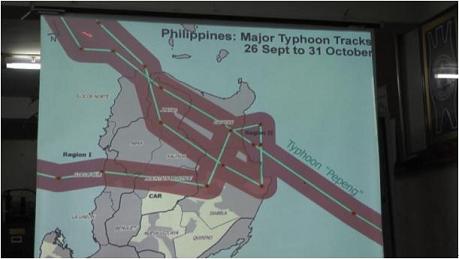
Figure 1. Track of T0917 around Luzon (from the presentation by Ms. Olive Luces (Regional Director, Cordillera Administrative Region, Office of the Civil Defense, Regional Disaster Coordinating Council) in Manila on 29 November, 2009).
In fact, satellite images of T0917 and T0918 showed a change of behavior from EI to PM, followed by PSO, and then separation of them. Specifically, T0917 and T0918 formed in succession around the Caroline and Marshall islands respectively around 29 September, 2009. At that time, T0918 was situated to the east of T0917. Both typhoons were then moved westward by easterly winds. Around the time T0917 landed on Luzon, T0918 was approaching T0917 at high speed, and the Fujiwhara effect caused T0917 to stagnate around Luzon (EI; around 3-4 October, Fig. 2a). As T0918 approached Okinawa, T0917 was absorbed and rapidly weakened by T0918 (PM; around 5-6 October, Fig. 2b). The weakened T0917 was blown south by a combination of the prevailing wind and the northerly winds generated by T0918 (PSO; around 7 October, Fig. 3c, see also Fig. 1 for southward movement.). Once the southerly movement of T0917 and north-easterly movement of T0918 had established a greater separation between them, T0917 regained its power and was moved west by an easterly wind (separation type; around 8 October, Fig. 2d). T0918 moved north-eastward and made landfall in Japan, becoming the only typhoon to do so in 2009.
The southward movement of T0917 was a typical consequence of the Fujiwhara effect because typhoons do not usually move southward. Similar behavior was also observed in T0015 (Bopha), which formed on 6 September, 2000, due to the interaction with T0014 (Saomai), which formed just before T0915 (Wu et al., 2003).
*) PAGASA is the abbreviation of The Philippine Atmospheric, Geophysical and Astronomical Services Administration.
**) The minimum pressures and maximum wind speeds are the values reported by Japan Meteorological Agency. The rainfall figures are the values reported at the actual location. Dates are expressed using Greenwich Mean Time (GMT).
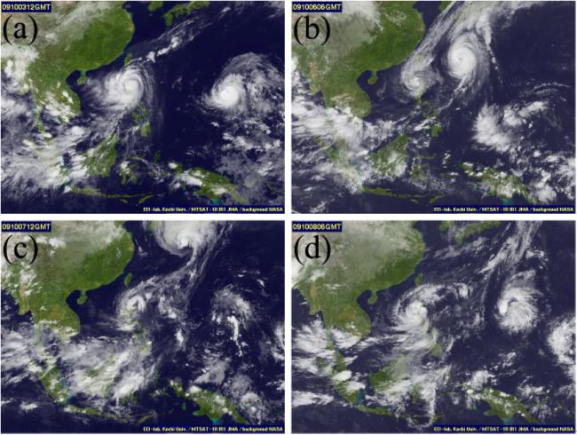
Figure 2. Infra-red satellite images of South-East Asia taken by the Multi-functional Transport Satellite (MTSAT-1R)(IR1: 10.3-11.3 μm) in 2009. (a) 12:00, 3 Oct., (b) 06:00, 6 Oct., (c) 12:00, 7 Oct., (d) 06:00, 8 Oct. In (c), T0918 is over the Japanese islands. In (d), T0918 is outside the frame of the image. These images were obtained from the Kochi University meteorology website (http://weather.is.kochi-u.ac.jp/).
- Fujiwhara, S. (1921): The natural tendency towards symmetry of motion and its application as a principle in meteorology, Q. J. Roy. Meteor. Soc., 47, 287-292.
- Lander, M. and G. J. Holland (1993): On the interaction of tropical-cyclone-scale vortices. I: Observations , Q. J. Roy. Meteor. Soc., 119, 1347-1361.
- Nyoumura, Y. (1986): A Typhoon Story-from the Record, Climb Publishing, Tokyo (in Japanese).
- Preito, R., B. D. Mcnoldy, S. R. Fulton, and W. H. Schubert (2003): A Classification of Binary Tropical Cyclone-Like Vortex Interactions, Mon. Wea. Rev., 131, 2656-2666.
- Wu, Chun-Chieh, Treng-Shi Huang, Wei-Peng Huang, and Kun-Hsuan Chou (2003): A New Look at the Binary Interaction: Potential Vorticity Diagnosis of the Unusual Southward Movement of Tropical Storm Bopha (2000) and Its Interaction with Supertyphoon Saomai (2000), Mon. Wea. Rev., 131, 1289-1300.
[ DIL TOP page | TOP page ]
