
Research Report on 2009 Floods and Landslides Disasters Caused by Typhoons 16(Ondoy), 17(Pepeng) and 18(Sante) in the Philippines
10. 2009 Typhoon Ondoy Flood in the Metro Manila.
10.1. The hydrological and geophysical environment of the Metro Manila
- (1)Hydrological environment
- (2)Flood-prone areas and the geophysical environment of flooding
- (3) Flood Control
10.2 Locality of flood disasters
10.3 Conclusion
10. 2009 Typhoon Ondoy Flood in the Metro Manila

Fig. 1 Map of Metro Manila (MMDA, 2009)
On 25-26 September 2009, Typhoon #16 (Ondoy) struck the south-western Luzon in Philippines, causing torrential rainfall. In 24 hours, 455.0 mm of rainfall fell in Quezon City's Science Garden, while 258.5 mm fell in the Port Area (Sept. 26), and 331.8 mm in the municipality of Tanay in neighboring Rizal province (Sept. 26). The amount of precipitation in the Science Garden reached levels only expected once per century (for rainfall in a 24-hour period) or once every 150 years (for rainfall in a 12-hour period), and the 92 mm of rain that fell between 11:00 and noon was of a level only expected once every 5-10 years (PAGASA, 2009). This heavy rainfall affected 872,097 people throughout the entire metropolitan area, causing 241 fatalities, 394 injured, and damaging 65,521 buildings (of which 12,563 were completely destroyed). The infrastructure damages (not including agricultural losses) amounted to 570,187,587 Philippine pesos (NDCC, 2009a). Other losses were caused by traffic coming to a standstill due to major city center thoroughfares such as Epifanio de los Santos Avenue (EDSA) being cut off by flood water, and the cancellation of domestic and international flights at Manila airport (Manila Shimbun, 27 Sept.).
In this chapter, we discuss the flood disasters that occurred in the Manila Metropolitan area (Metro Manila), which is a major city in a developing country, and one of south-east Asia's most prominent overpopulated centers which is expected to grow to a population of 25 million by 2015 (JICA, 2004). As Fig. 1 shows, Metro Manila comprises 17 cities, all of which lie within the Pasig-Marikina-Laguna Lake Complex (catchment area: 4,678 km2>) except for parts of the north and the southernmost tip which lie along Manila bay (Fig. 2). This chapter relates to the 2009 Ondoy flood that took place in this river basin.
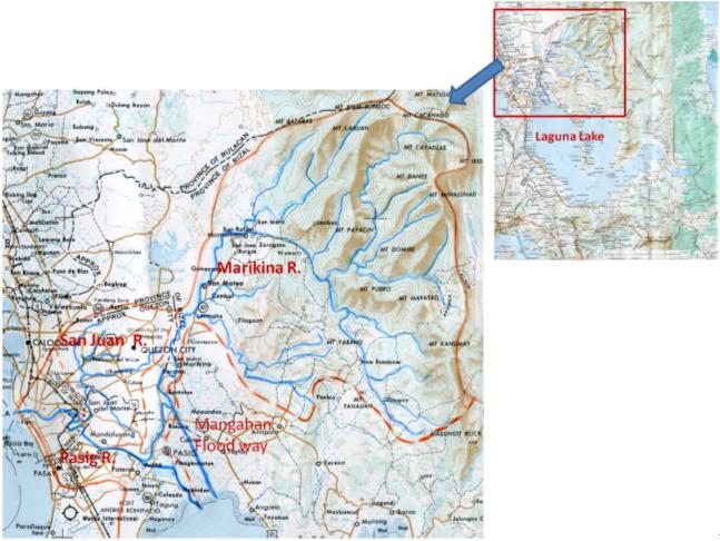
Fig. 2 Maps of the Pasig -Marikina -Laguna Lake Complex
(NAMRIA Geographical Map 1:250,000)
Hydrological and geophysical environments of Metro Manila.
(1) Hydrological environment
As its name suggests, the Pasig-Marikina-Laguna Lake Complex consists of two rivers and one lake. One of these is the Marikina River, which has a catchment area of 516.50 km2 (at the Napindan junction) and flows out from the Sierra Madre mountain range in the east part of the river basin. The Marikina River meanders its way southwards along the Marikina River flood plain, and floodwater is diverted into the Manggahan floodway from the Rosario weir in the left bank, where the Upper Marikina River becomes the Lower Marikina River. The Lower Marikina continues southwards, and at Napindan junction it is joined by the Pasig River that flows north from Laguna de Bay (Laguna lake). The Pasig River is the only river that flows out from Laguna de Bay. The Napindan channel flows north from the north coast of Laguna de Bay, and where it joins the Marikina River, it starts to flow northwest across the central plateau and into the coastal lowland alongside Manila bay, and then out into the bay near the old city district at the center of the lowland area. The Pasig River flows is joined by the San Juan River as a right tributary which has the central plateau as its river basin.
With an area of 900 km2, Laguna de Bay is the largest lake in the Philippines, occupying a large region extending from the central to southern parts of the river basin. The lake has a catchment area of 3,820 km2, which is about 80% of the total catchment area. This wide and shallow lake temporarily stores the water flowing from at least 20 tributary river basins, and during floods it functions as a retarding reservoir for the Marikina River. When the sea level in Manila bay is higher than the water level in the lake, the water flows backwards from the sea into the lake.
(2)Flood-prone areas and the geophysical environment of flooding
The flood-prone area in the Pasig-Marikina-Laguna Lake Complex can be divided into the following four flood plains as depicted in the flood hazard map of Fig. 3:
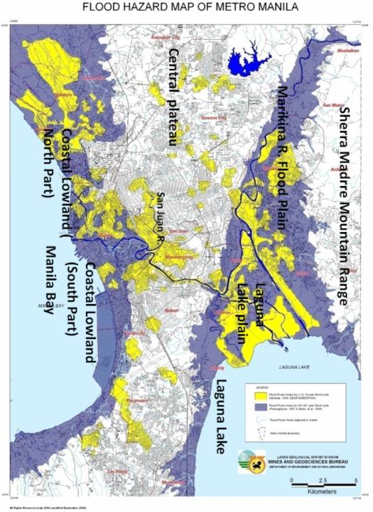
Fig. 3 Flood hazard map of the Metro Manila (MGB, 2009)
1) Coastal lowlands alongside Manila bay: Land with an altitude of 3 meters or less next to Manila bay down the Pasig River. This lies at the center of Metro Manila.
2) Marikina flood plain: Alluvial lowland with an altitude of 5-30 m along the Marikina River, which is being developed to the north and south at the western end of the river basin. It is bounded to the west by the central plateau that lies between the Manila bay coastline and the coastal lowlands, and to the east by the Sierra Madre mountain range from where the Marikina River originates.
3) Laguna Lake Plain: The Marikina flood plain continues on into the lake plain of Laguna de Bay. This is a marshy plain with an altitude of just a few meters.
4) Valley plains cutting through the central plateau: Lowland areas alongside the Pasig and San Juan Rivers where they cut across the central plateau.
In these flood plains, even floods with an estimated frequency of 2-10 years (shown in yellow) are liable to cover a substantial part of these areas, while floods with an estimated frequency of 50-100 years (blue) are liable to cause flood damage over the entire flood plain (Fig. 3). A common problem of rice-growing areas in the Asian monsoon region is that urbanization driven by population growth can lead to building development on low-lying flood plains that are used for rice paddy fields and such like, resulting in greater potential losses in the event of a flood disaster. Metro Manila is no exception. For example, half a century ago (around 1966), the residential areas in the low-lying Laguna Lake plain were confined to the natural levee and a high coastal terrace (4-7 m above sea level), but gradually they have encroached into lower-lying areas while filling in the poorly-drained back marshes, and the developments have now reached as far as the delta on the shores of the lake. The change in landscape brought about by filling in these marshes has also created an artificial flood-prone basin and changed the spatial distribution of flooding, which has affected the hazard situation (Hara et al., 2002).
Another factor behind the increased damage potential is the growth of illegal settlements. In the Manggahan floodway, for example, buildings have been erected in places such as floodwater channels that have an extremely high risk of flood damage, thus giving rise to a larger number of fatalities. Furthermore, there are many places in the flood plains where flood water is not adequately drained away. This results in water being retained for long periods, causing environmental contamination that has an adverse effect on living conditions and can lead to major outbreaks of infectious disease after a flood disaster has struck. Typhoon Ondoy caused 241 fatalities in the Metro Manila area, but 74% of these were as a result of infectious disease (NDCC, 2009a). This environmental contamination is accelerated by pollutants from small and medium-scale factories in the river basin, which become mixed in with the flood water.
(3)Flood Control
The key component of Metro Manila's flood control is the Manggahan floodway, which has a drainage capacity of 2,400 m3/sec and is designed for once per century flood discharge. By diverting 70% of the Marikina River flood discharge into Laguna de Bay from the Rosario weir to reduce the flood discharge that continues downstream to the Pasig River, it is possible to reduce the flood inundation of the Pasig River flowing through the city center. When Typhoon Ondoy struck, flood water was diverted from the Marikina River into Laguna de Bay at a rate of 3,000 m3/sec, and only a partial external overflow occurred in the Pasig River so it was possible to continue operating the inner water drainage pumps (MMDA,2009; P.B.GATAN,2009) .
The Pasig and Marikina Rivers are designed to withstand floods with an designed scale of 30 year flood (Marikina River: 2,600-2,900 m3/sec, Pasig River: 500-600 m3/sec in the middle section and 1,200 m3/sec in the lower reaches), but the design discharge capacity is only actually achieved in the middle section of the Pasig River. The drainage of other areas is incomplete. For example, the current discharge capacity of the Marikina River is 1,500-1,800 m3/sec, which is smaller than the design scale. To protect the regions that open out onto the Laguna Lake Plain to the west of the Manggahan floodway (Taguig, Pateros and Pasig Cities) from becoming inundated due to a rise in the water level of Laguna de Bay, work is under way to construct a 9.5 km Coastal bank along the Lake, 8 weirs and 4 drainage pump stations (MMDA,2009; P.B.GATAN,2009). These inner water drainage facilities helped to reduce the flooding duration of the inner water inundation caused by Typhoon Ondoy (JICA, 2009).
While flood control maintenance is continuing, various problems have arisen such as the increasing scale of hazards in the river basin and the reducing functionality of flood control facilities. With regard to the former, the changing patterns of land use associated with haphazard development are changing the scale of flood discharge and the spatial distribution of flood inundation, and with regard to the latter, the drainage performance is being impaired due to the disposal of garbage and construction of shanty towns in drainage channels. For example, in the city center district which is developing into the low-lying areas along the Manila bay, the urban discharge channels for discharging inner water are constructed every ten years, but the discharge capacity of these channels has decreased to the point where they can only handle rainfall of a level expected to occur once every 2 to 5 years (JICA, 2005). These are complex issues involving a variety of social, economic and governmental factors.
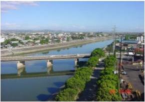
Photo 1 Manggahan Floodway (MMDA,2009)
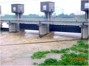
Photo 2 Rosario Weir of the Manggahan Flood way (MMDA,2009)
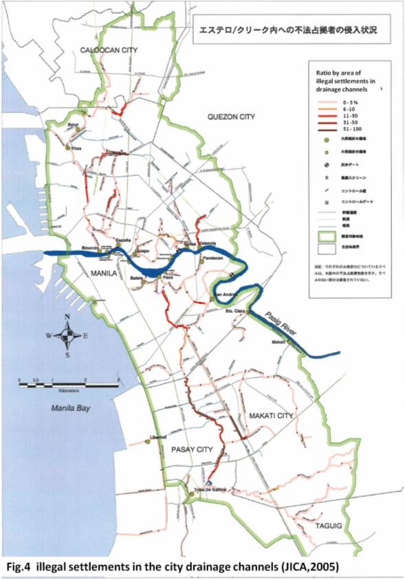
Figure 4 illgal settlements in the city drainage channels(JICA,2005)
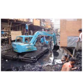
Photo 3 Dredging urban drainage channels
in the Metro Manila (MMDA,2009)
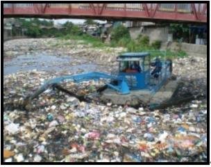
Photo 4 Dredging urban drainage channels
in the Metro Manila (MMDA,2009)
[ DIL TOP page | TOP page ]
